Grand Canyon (March 2016)
The trip started in Page, AZ with a tour of Upper Antelope Canyon, which was followed by watching the sun set over horseshoe bend. The next morning we embarked on a 4-day, 3-night backcountry camping trip in the Grand Canyon dropping from Lipan Point to the Colorado River on the first day and having a long uphill hike out to Grandview Point on our last day. Each part of the trip was uniquely special with its own beauty accompanied by a fair amount of struggling in the Canyon! It's a trip I would repeat in a heartbeat.
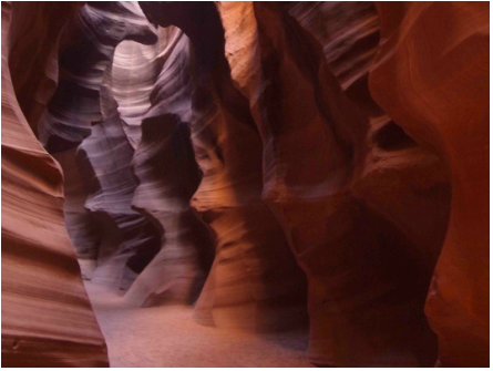
Upper Antelope Canyon
My girlfriend and I began our 16 hour road trip in the morning with our eyes set for the Grand Canyon. I sometimes enjoy winging portions of my adventures, but as this was our second trip together I thought I had prepared our itinerary quite thoroughly - wrong! I forgot to reserve a site at Mather Campground ahead of time, so we called to inquire about reservations and found out they were completely booked. Fairly easy to believe once you realize it is spring break for most students, so who wouldn't want to go to the Grand Canyon! So here comes flying by the seat of my pants…
An hour's worth of brainstorming with the help of the internet and voila(!), we have reservations for Upper Antelope Canyon tomorrow afternoon and an inexpensive room in Page, AZ. As I like to say whenever anything isn't going according to plan, "it'll all work out. And if it doesn't, then something else will". Well to say that it worked out would be an understatement. Page is a beautiful little city located just south of the Arizona/Utah border. Last year, I stopped there for 7 hours of sleep on my way to Bryce Canyon and Zion, but gave it little attention. Fortunately, I was able to make up for my previous mistake.
We booked a tour through Antelope Slot Canyon Tours (a guide is required to enter the canyon) for the afternoon. The tour started with an authentic hoop dance, which was incredibly impressive, before we hopped into the back of trucks and drove the 15 minutes to the canyon. The ride out to the Canyon feels like you are going to the middle of nowhere and once you enter the area for Upper Antelope Canyon it is hard to imagine where this canyon is! However, once you enter the little crack in the canyon, you feel as though you have been transported into a different world. The air is moist, almost as if you are in a cave. You look around and see the walls beautifully illuminated by the tiny bits of light coming in through the top of the canyon. The tour guide knows that most people are yearning to snap a National Geographic-worthy photo, so he instructs people the best settings for their cameras as he points out the silhouette of a bear in one section, the head a president in another, and even the face of King Kong! The most beautiful portion of the whole tour comes when everyone is quietly taking pictures and he begins to play an indigenous flute - the serenity and wonder of the canyon simply came to life.
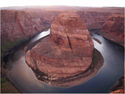
Horseshoe Bend
Last year on our way back from Zion National Park, my car was debating whether we should stop at Horseshoe Bend or drive straight to Petrified Forest National Park, so we could make it in time before it closed. Petrified Forest National Park was a nice pitstop, but in retrospect, we made a big mistake… Horseshoe Bend is spectacular! As one might guess, Horseshoe Bend derived its name from the curve in the river that is shaped like a horseshoe. With my background in environmental and water resources engineering, this site leaves me speechless of how this section came to be! I have never seen anything like it before, nevertheless at such a grand scale. The entrance is located only 10 minutes away from the center of Page, so we drove over right around 6:00 p.m. as the sun was setting around 6:30 p.m. The parking lot was full, yet there were plenty of spots along the canyon's rim to feel as though you were fairly isolated from everyone. The rim of the canyon looks west over the bend making it a perfect place to catch the sunset. As luck would have it, a couple of clouds rolled into the horizon bringing the sunset even further to life. I've always been a sucker for a good sunrise or sunset, especially while on a camping trip, and this was certainly a special one.
Last year on our way back from Zion National Park, my car was debating whether we should stop at Horseshoe Bend or drive straight to Petrified Forest National Park, so we could make it in time before it closed. Petrified Forest National Park was a nice pitstop, but in retrospect, we made a big mistake… Horseshoe Bend is spectacular! As one might guess, Horseshoe Bend derived its name from the curve in the river that is shaped like a horseshoe. With my background in environmental and water resources engineering, this site leaves me speechless of how this section came to be! I have never seen anything like it before, nevertheless at such a grand scale. The entrance is located only 10 minutes away from the center of Page, so we drove over right around 6:00 p.m. as the sun was setting around 6:30 p.m. The parking lot was full, yet there were plenty of spots along the canyon's rim to feel as though you were fairly isolated from everyone. The rim of the canyon looks west over the bend making it a perfect place to catch the sunset. As luck would have it, a couple of clouds rolled into the horizon bringing the sunset even further to life. I've always been a sucker for a good sunrise or sunset, especially while on a camping trip, and this was certainly a special one.
Lipan Point to Grandview Point
Day One
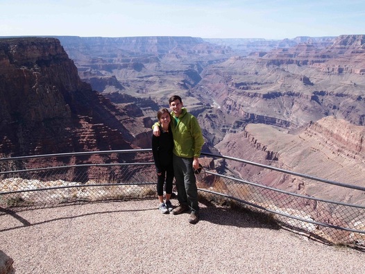
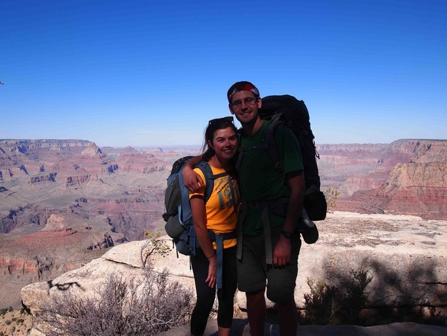
The drive from Page to the entrance of the Grand Canyon National Park is only a little over 2 hours away, which made Page an excellent rest point. As we entered the Grand Canyon, it was hard to believe that we had visited Horseshoe Bend and Upper Antelope Canyon only the day before. We got into the park just before noon and made our way over to Grandview Point. Grandview Point has an overnight parking area for backcountry campers, which makes it a particularly convenient end point. We arranged for a taxi to come pick us up and drop us off at Lipan Point. For $44 this seems like a steal - who knew that there were cabs in the Grand Canyon? The driver dropped us off and we took a few photos together while we were still clean before descending into the canyon.
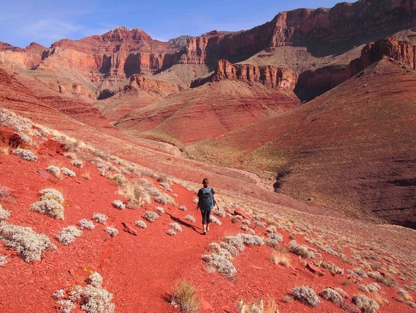
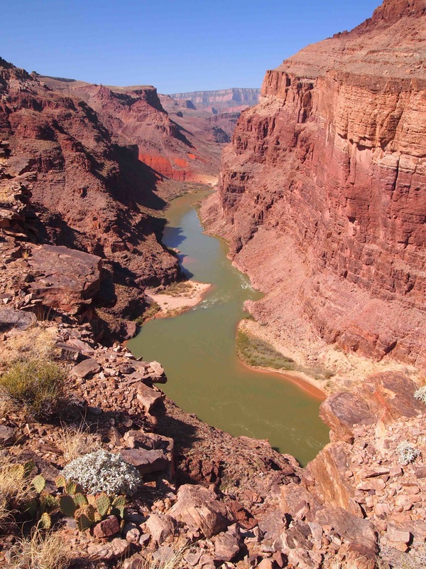
As one might expect, the Tanner Trail, which takes you down to the Colorado River (~1 mile lower in elevation), starts off by going straight downhill. This made the snow/ice-covered portions of the trail a little bit sketchy. For the most part the excitement of the start of an adventure provided plenty of energy to ignore the weight of my pack and the load it was placing on my knees. After a couple hours though, my knees naturally started asking for a break, and fortunately the Tanner Trail provides this around Escalante Butte. This also coincided with a nice stretch of being able to look around and realize how lucky I was to be standing in the middle of the Grand Canyon with the rim of the canyon towering of you in every direction and knowing that you haven't even dropped halfway down yet. As the trail continues to curve around Cardenas Butte, the Colorado River and Tanner Rapids comes into sight and it looks quite far away!
Day One
The drive from Page to the entrance of the Grand Canyon National Park is only a little over 2 hours away, which made Page an excellent rest point. As we entered the Grand Canyon, it was hard to believe that we had visited Horseshoe Bend and Upper Antelope Canyon only the day before. We got into the park just before noon and made our way over to Grandview Point. Grandview Point has an overnight parking area for backcountry campers, which makes it a particularly convenient end point. We arranged for a taxi to come pick us up and drop us off at Lipan Point. For $44 this seems like a steal - who knew that there were cabs in the Grand Canyon? The driver dropped us off and we took a few photos together while we were still clean before descending into the canyon.
As one might expect, the Tanner Trail, which takes you down to the Colorado River (~1 mile lower in elevation), starts off by going straight downhill. This made the snow/ice-covered portions of the trail a little bit sketchy. For the most part the excitement of the start of an adventure provided plenty of energy to ignore the weight of my pack and the load it was placing on my knees. After a couple hours though, my knees naturally started asking for a break, and fortunately the Tanner Trail provides this around Escalante Butte. This also coincided with a nice stretch of being able to look around and realize how lucky I was to be standing in the middle of the Grand Canyon with the rim of the canyon towering of you in every direction and knowing that you haven't even dropped halfway down yet. As the trail continues to curve around Cardenas Butte, the Colorado River and Tanner Rapids comes into sight and it looks quite far away!
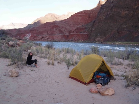
Here's where I learned my first lesson in planning a trip in the Grand Canyon - always start REALLY early in the morning. In the summer this is crucial to avoid the midday heat. While this was not an issue for us in March, it would have been nice to get to Tanner Beach with plenty of daylight left to relax on its banks and take a quick dip in its frigid waters. The trail from Cardenas Butte downward does a number on your ankles as there are many parts where you are literally walking on the side of a slope, which applies a strange amount of pressure on the joints and edges of your feet. This section of the trail is very well marked, likely because its fairly well traveled, which provides countless opportunities to look ahead and see all the switchbacks in your future! We arrived at Tanner Beach (BB9) about an hour before dark and found a great flat spot on the sand with the sound of the rapids roaring close by.
Day Two
All the downhill from the previous day gave the calves and the quads a nice workout, which made for an easy night sleep! The temperature at the river is also 20 degrees warmer than on the rim, which made the low likely somewhere in the upper 40s, which is almost perfect for sleeping. Since we were fairly tired and got in late, we took our time getting started in the morning. We prepared our breakfast and pumped water from the river, which wasn't as silty as I was expecting. Nonetheless, I wrapped a bandana around the intake of my Katadyn Hiker Pro water filter and deliberately found a slower moving section of the river to try and reduce the load of suspended solids my filter would have to handle. This simple trick seemed to do the trick, although one gentleman that was also camped at Tanner Beach said when he was there in November the water was dark with sediment, so perhaps we just got lucky! I'll take it.
We hopped on the trail around 9:30 a.m. with the intention of getting into the Red Canyon area (BD9). Here is where I learned another valuable lesson: when the permit says "route-finding skills required", next time I need to trust that the route isn't going to be clearly marked all the time. As you might guess, we instantly started off going down the wrong trail. The beach camping sites are tricky in this regard because there are so many paths from people wandering around to find their perfect tent site or swimming hole that paths look to be well traveled thereby giving the appearance that they are the trail, but they are not. As we'd come to learn after 4 days, the proper trail when entering/exiting these beach areas are well marked with cairns. So off we went down the wrong trail getting lost less than 30 minutes into our second day on the trail. Fortunately, after a half hour we were able to find our way back onto the main trail and continue on. As we looked back to see where the trail actually was, we were happy to see a group behind us making the exact same mistake. I waved my temporary hiking stick of driftwood at the group and tried to point them in the right direction and we continued on.
This section of the trail along the Escalante Route hugs the river for a while before heading inland, which comes with a great deal of elevation gain! The trail is well traveled, which makes the footing nice and easy such that you can look up and take in the buttes and rim of the canyon as you hike. I was zoning out a bit and looking at the rim when all of the sudden there was a loud rattling noise directly in front of me!! YIKES! When I looked down there was a 3' long rattle snake making a great deal of noise only 2' in front of me! For anyone who knows me, I absolutely hate snakes and definitely jumped back with a yell (Aaaa-yeeee) as the snake seemingly calmly went slightly off the trail around me and settled underneath a rock. With the adrenaline pumping, we started walking quite rapidly, while staring down at our feet(!), to get away from our dear friend. Looking back, I'm thankful he was relatively friendly all things considered.
After our rattlesnake scare, we continued onward and realized that we missed the spot where we should have filtered more water. This wasn't really an issue because we had enough to make it to the next spot on the river, but I typically like to err on the side of extreme caution and lug the extra water weight to be safe. We contemplated turning around and hiking a half hour back to the river, but (1) we had already wasted a lot of time and had gotten a late start, (2) we had enough water to be safe, and (3) our dear pal was on the path between us and the river and I'd heard enough rattling for one day. Once we reached the highest point of this days hike, we stopped for lunch in the shade of a large boulder. After a very brief rest, we continued on and came across a troop of Boy Scouts from Phoenix. They were very friendly, so we stopped and spoke with them briefly. They were spending many more days than we were on the trail, so were stopping along this plateau for the night. This meant they had to carry all their water up for the rest of the night AND the next morning - I got the impression the leaders had some pretty heavy packs. They would end up coming to our rescue the next day (stay tuned!).
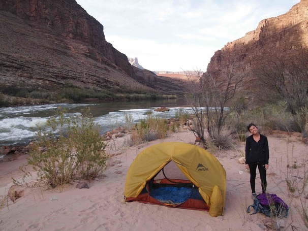
By the time we reached the river again it was around 4 p.m. The sun was bright and the beach was nice and warm. We had been rationing our water just in case, so we took our time rehydrating and savoring the nice cold water of the Colorado. We also found this spot located about a half mile upriver from Neville Rapids had some of the most beautiful beach camping sites I had ever seen. Best of all, it looked like we had it all to ourselves and with the rattlesnake scare and the lost time at the start, we decided this would be a great campsite and we'd make up the difference tomorrow. We found a nice little eddy in the rocks right off the beach and I jumped right in! It felt gloriously refreshing! After relaxing on the rocks and in the eddy while we cleaned up and filtered water, we set up our tent and had dinner. Once again, we were thoroughly exhausted and with the peaceful sound of the river running over little rapids close by, we slept quite soundly.
By the time we reached the river again it was around 4 p.m. The sun was bright and the beach was nice and warm. We had been rationing our water just in case, so we took our time rehydrating and savoring the nice cold water of the Colorado. We also found this spot located about a half mile upriver from Neville Rapids had some of the most beautiful beach camping sites I had ever seen. Best of all, it looked like we had it all to ourselves and with the rattlesnake scare and the lost time at the start, we decided this would be a great campsite and we'd make up the difference tomorrow. We found a nice little eddy in the rocks right off the beach and I jumped right in! It felt gloriously refreshing! After relaxing on the rocks and in the eddy while we cleaned up and filtered water, we set up our tent and had dinner. Once again, we were thoroughly exhausted and with the peaceful sound of the river running over little rapids close by, we slept quite soundly.
Day Three
We woke up feeling nice and sore, but when we hopped out of our tent we couldn't believe how lucky we were. The sun was just beginning to rise over the canyon rim and the temperature was fairly warm all things considered. There were pieces of driftwood on the beach that previous hikers had turned into benches and tables, so we sat on the bench, cooked breakfast, and savored a cup of hot chocolate. We had this entire beautiful beach all to ourselves and decided to savor every minute of it this morning. Unfortunately, that meant another late start (10:00 a.m.) for hopping on the trail. This wouldn't have been a problem had we stayed on course…
Once again, after a little over an hour and a half we realized that we hadn't seen a cairn in a while. The path that we were on was incredibly well traveled and when we looked at the map, we were right next to the water just like the trail on the map showed. Only problem was that we were a couple hundred feet above the water on the rim of a cliff and we were supposed to be right next to the water on the beach. We turned around and went back to find the trail once again and fortunately, on the opposite side of the rim of a slot canyon, stood our trusted Boy Scout friends. I believe the slot canyon is called 75 mile canyon (when I recounted our story of getting lost to a father and his family the next day, he said that he had done the exact same thing the first time he did this hike as well - no wonder the "lost" path we were on seemed so well traveled!). Our friend hollered across the canyon and told us that we were actually supposed to drop into the slot canyon rather than stay on the rim as we had done. So we waved thank you and went on our way back on the right track - if that Boy Scout leader ever reads this, I don't remember his name, but thank you so much for the help that day!! I'll try to pay it forward as best I can.
Unfortunately, we had wasted approximately 2 hours by this time and were now well behind our original itinerary. We tried hiking quickly to pick up the pace, but by this time it was noon and was probably around 80 - 90 degrees. Not to mention that the trail on the beach of the river was really a trail next to the river that was filled with rock scrambles. I typically love these sections of trails, but after being lost and realizing that we wasted all that time and energy I was ready to move along. That was until the rock scrambles turned into climbing a cliff… is that a cairn that I see up ahead? How on earth am I supposed to get to that cairn? As I look back, I see the cairn that we just passed… whoever built this trail sure had an adventurous spirit! This section wouldn't have been too bad with a day pack, but with tired legs and a 30-ish lb pack on my back, it wasn't the most pleasant. Nonetheless, onward we went, albeit as slowly and carefully as possible. The straight up rock scrambling that we just completed shortly turned into a straight down rock scramble - perfect! The only thing I could think of besides making sure that my girlfriend was alright/safely managing her way down was that this must be how our porters feel when they're carrying heavy loads of our equipment onto the debris-covered glaciers. Our porters carry our gear while we are in the field such that I only have to carry a daypack, but we're constantly climbing up and down steep loose sections of debris that was very similar to our current path. Those guys are truly remarkable and I could not perform my research without them, but back to our current situation!
We safely navigated our way down this steep section and finally wound up on flatter terrain. At this point and time it was 2:00 p.m. and we had not had lunch yet. The original plan was to reach here by noon, grab lunch, filter water, and make our way up towards Horseshoe Mesa, but we realized that today was not our day and that it was better for us to be safe. I'm not going to lie, it felt like a bit of a shot to my pride to not complete what I had set out/planned to do, but in these situations it's more important to be safe. So we ended up camping on the beach of Hance Rapids and were left with a good bit of free time. I quickly washed away that shot to my pride with a dip in the refreshing water of the Colorado and a tasty meal. We spent the next couple of hours doing yoga and relaxing on the beach, which was way better than trying to book it uphill on tired legs to beat the setting of the sun… it was a great adjustment and had the benefit of allowing us to spend one more night on the beach of the Colorado River. These three nights of camping were some of the best I've ever had. The sky was crystal clear and with an almost full moon, there was no need to have a headlamp at night as the moon and stars were more than bright enough to see your path on the beach.
Day Four
We decided yesterday that we were going to make up for the lost time yesterday and hike out of the canyon today. This was going to require quite the effort as the hike out up to Grandview Point is approximately 10 miles with a full mile of elevation gain. I set my alarm to wake us up well before sunrise, so we were on the trail by 7 a.m. Here is where I learned how beautiful it would have been had we started this early each morning(!) and finished each day early enough to enjoy a swim in the water and have plenty of time to air dry in the canyon sun. After getting partially lost once each of the past two days, we made sure that we weren't going to waste our time getting lost again. Here is when we learned that the paths exiting the beaches are well marked with cairns.
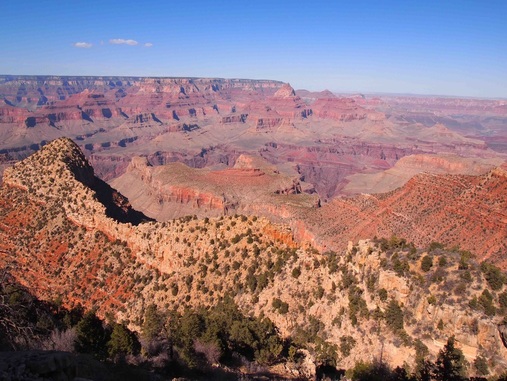
The hike from the river to the rim was beautiful as it ventured its way through various terrains and each gain in elevation gave a drastically different perspective of the Canyon. For a significant stretch the trail followed a beautiful section of red rock, this section was also behind a Butte, which extended our time in the shade - a great bonus! As we continued to climb, the rocky desert gave life to various sorts of cacti. We quickly were no longer able to see the Colorado River, but started seeing further into the canyon. However, every time that we looked up thinking that we found the spot that was potentially Grandview Point, we'd hike another couple hours and realize that we were nowhere close! There are so many little rims and false summits within the canyon that it was truly spectacular. Page Spring was a great little rest point halfway through our day, where we were able to fill up our water bladders for one last time. We only rested as long as it took to pump all our water such that we could make good time getting back to the car. It was along this route that we started seeing many more people. Once we reached the first plateau of Horseshoe Mesa, which required a great deal of switchbacks just to get there(!), we started encountering many day hikers that were simply hiking down to get a different vantage point of the canyon and hike back to their cars. It was a nice feeling to realize we were now within the range of day hikers - only to realize that wow, they really can hike a lot faster than we can with so little weight!
We decided yesterday that we were going to make up for the lost time yesterday and hike out of the canyon today. This was going to require quite the effort as the hike out up to Grandview Point is approximately 10 miles with a full mile of elevation gain. I set my alarm to wake us up well before sunrise, so we were on the trail by 7 a.m. Here is where I learned how beautiful it would have been had we started this early each morning(!) and finished each day early enough to enjoy a swim in the water and have plenty of time to air dry in the canyon sun. After getting partially lost once each of the past two days, we made sure that we weren't going to waste our time getting lost again. Here is when we learned that the paths exiting the beaches are well marked with cairns.
The hike from the river to the rim was beautiful as it ventured its way through various terrains and each gain in elevation gave a drastically different perspective of the Canyon. For a significant stretch the trail followed a beautiful section of red rock, this section was also behind a Butte, which extended our time in the shade - a great bonus! As we continued to climb, the rocky desert gave life to various sorts of cacti. We quickly were no longer able to see the Colorado River, but started seeing further into the canyon. However, every time that we looked up thinking that we found the spot that was potentially Grandview Point, we'd hike another couple hours and realize that we were nowhere close! There are so many little rims and false summits within the canyon that it was truly spectacular. Page Spring was a great little rest point halfway through our day, where we were able to fill up our water bladders for one last time. We only rested as long as it took to pump all our water such that we could make good time getting back to the car. It was along this route that we started seeing many more people. Once we reached the first plateau of Horseshoe Mesa, which required a great deal of switchbacks just to get there(!), we started encountering many day hikers that were simply hiking down to get a different vantage point of the canyon and hike back to their cars. It was a nice feeling to realize we were now within the range of day hikers - only to realize that wow, they really can hike a lot faster than we can with so little weight!
Throughout the morning we joked about how strong we felt and how we must have developed our trail legs. I'm sure my dad would have a good laugh at that one, seeing how he's been on the Appalachian Trail for over a month and still says that he hasn't hit that point or found his hiker hunger yet. The way that I downed the peppered salami with tortillas for lunch, I sure felt that I had my hiker hunger! The benefit of a long straight uphill section is that it forces you to stop and rest quite a bit. Once we were above Horseshoe Mesa and onto Grandview Trail, these breaks were accompanied by spectacular views. For a time we could see the canyon where we had been 4 hours earlier and then that slowly seemed to blend in with all the other canyons that were so far down and close to the river. Once again, we constantly were looking up at the rim trying to guess which one was Grandview Point - I'm pretty sure we were wrong every time because there are so many smaller canyons within one another that it felt never-ending. Although that was one of the most beautiful things about our trek: we had spent 4 days in the canyon and got to experience all its different levels, feel the changes in the temperature, see the changes in the vegetation, and have many different vantage points from within the canyon. By the time we made it out around 3:30 p.m., we were absolutely ecstatic and felt incredibly accomplished! I don't think I ever need to come that close to a rattlesnake again and certainly will be much more diligent of ensuring we're on the proper trail, but similar to Page, I would return in a heartbeat. The Grand Canyon was absolutely spectacular and while I felt that I had gotten a good feel for it, as we drove out of the park and saw the countless other views the canyon has to offer, I realized that I only scratched the surface. I can't wait to come back.
