RESEARCH INTERESTS
Glacier mass change; glacier hydrology and meteorology; glacier hazards; coupled field and modeling studies; remote sensing; computational modeling; linkages between glacier change, water security, and hazards; climate change; sea-level change
Glacier mass change; glacier hydrology and meteorology; glacier hazards; coupled field and modeling studies; remote sensing; computational modeling; linkages between glacier change, water security, and hazards; climate change; sea-level change
OVERVIEW
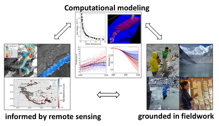
My research group seeks to quantify the response of glaciers, water resources, and hazards to climate change to inform adaptation and mitigation efforts at local, regional, and global scales. Our work uses computational models informed by remote sensing and grounded in fieldwork to produce actionable information. Currently, we seek to quantify how glaciers across the globe will respond to climate change to help stakeholders plan for future increases in sea level, changes in water resources, and hazards associated with glacier outburst floods. Below is a bit more about our research concerning glacier projections, debris-covered glaciers, and glacier outburst floods.
My research group seeks to quantify the response of glaciers, water resources, and hazards to climate change to inform adaptation and mitigation efforts at local, regional, and global scales. Our work uses computational models informed by remote sensing and grounded in fieldwork to produce actionable information. Currently, we seek to quantify how glaciers across the globe will respond to climate change to help stakeholders plan for future increases in sea level, changes in water resources, and hazards associated with glacier outburst floods. Below is a bit more about our research concerning glacier projections, debris-covered glaciers, and glacier outburst floods.
Glacier Mass Change and Runoff Projections
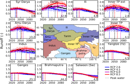
Glaciers, excluding ice sheets, are responsible for ~30% of present-day sea level rise. Projecting glaciers’ response to climate change thus has major impacts on sea level rise and water resources. I have developed an open-source global glacier evolution model called the Python Glacier Evolution Model (PyGEM) to project glacier mass change and changes in glacier runoff for various scenarios of climate change using general circulation models (GCMs) and representative concentration pathways (RCPs) through 2100. One of the major advances with PyGEM is the calibration scheme that leverages geodetic mass balance datasets using bayesian inference to capture subregional variations in glacier mass change and runoff. In the near future, we are seeking to improve how PyGEM accounts for debris-covered glaciers, glacier dynamics, and frontal ablation.
Glaciers, excluding ice sheets, are responsible for ~30% of present-day sea level rise. Projecting glaciers’ response to climate change thus has major impacts on sea level rise and water resources. I have developed an open-source global glacier evolution model called the Python Glacier Evolution Model (PyGEM) to project glacier mass change and changes in glacier runoff for various scenarios of climate change using general circulation models (GCMs) and representative concentration pathways (RCPs) through 2100. One of the major advances with PyGEM is the calibration scheme that leverages geodetic mass balance datasets using bayesian inference to capture subregional variations in glacier mass change and runoff. In the near future, we are seeking to improve how PyGEM accounts for debris-covered glaciers, glacier dynamics, and frontal ablation.
Debris-Covered Glaciers
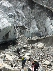
Debris thickness controls how glaciers will respond to climate change as a thin layer will enhance melting, while a thick layer will insulate the glacier and reduce melting. While more than 40% of glaciers (up to 75% in some regions) can be classified as debris-covered, few glaciers have debris thickness measurements. Field expeditions near Everest Base Camp in Nepal have allowed me to measure debris properties, sub-debris melt, and meteorological data, which have been used to advance energy balance models. These models can be combined with remote sensing data to estimate the spatial distribution of debris thickness; thus allowing debris cover to be properly accounted for in projections of glacier mass change.
I also co-lead an International Association of Cryospheric Sciences (IACS) working group on debris-covered glaciers that comprises more than 40 scientists who seek to foster knowledge exchange and perform model comparisons to advance our ability to map debris thickness and estimate sub-debris melt.
Glacier Outburst Floods
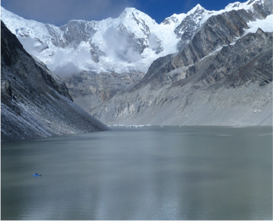
As glaciers retreat in response to climate change, the number and size of glacial lakes are increasing around the globe. These glacial lakes have the potential to be a significant flood hazard for downstream communities. Understanding how glacial lakes and triggering events like avalanches and landslides will respond to climate change therefore has important socioeconomic impacts. During my PhD, I was a part of Dr. Daene McKinney's research team, where we sought to quantify the hazard and risk associated with Nepal's second largest glacial lake, Imja Lake. We measured lake bathymetry, ice thickness from ground penetrating radar, lake water level, flow rates, and seepage rates to inform hydrodynamic flood models and ultimately determined that Imja Lake did not pose a significant risk to downstream communities. I therefore developed methods using remote sensing and numerical models to assess the hazard and risk of every glacial lake in Nepal to identify the most dangerous glacial lakes in order to help inform future risk-mitigation efforts.
I also continue to be involved in numerous rapid reconnaissance efforts to inform disaster relief efforts, identify secondary hazards, and determine the cause of floods. After the Gorkha Earthquake in 2015, I helped identify landslides, landslide-dammed lakes, and glacier outburst floods using remote sensing. In 2017, after a flood occurred in Nepal with unknown origins, we worked with local communities, conducted fieldwork, and used satellite imagery to determine that a large rockfall entered a nearby glacier lake and triggered the outburst flood. As glaciers retreat, the frequency of glacier outburst floods is expected to increase.
Fieldwork
There is no better office than the field. Whether it be the Himalayas, Alaska, or Cordillera Blanca, fieldwork fosters community-driven research and provides key information to ground computational models and remote sensing observations. A few highlights have been kayaking in Lumding Tsho to measure its bathymetry and installing ablation stakes and temperature sensors to understand glacier melt rates in the Nepal Himalaya. However, the best part of fieldwork will always be the interactions with my colleagues and local community members. If you're interested in learning more please send me an email or check out my blog about recent expeditions.
Interested in learning more? Please send me an email, check out my blog, or view my publications or information on Google Scholar.
